
NASA Satellite Captures Mesmerizing Swirling Cloud Formations Off Alaska’s Coast
NASA Satellite Captures Mesmerizing Swirling Cloud Formations Off Alaska’s Coast
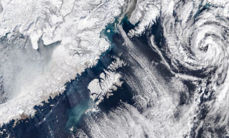
The rugged, icy waters off the coast of Alaska are no stranger to extreme weather, but recently, the region served as the canvas for a breathtaking atmospheric display. NASA recently released striking satellite imagery of massive, swirling cloud formations cascading over the ocean, a phenomenon that looks more like brushstrokes on a painting than a meteorological event. These dramatic patterns, scientifically known as von Kármán vortex streets, offer a visually stunning reminder of the complex fluid dynamics occurring constantly above our planet.
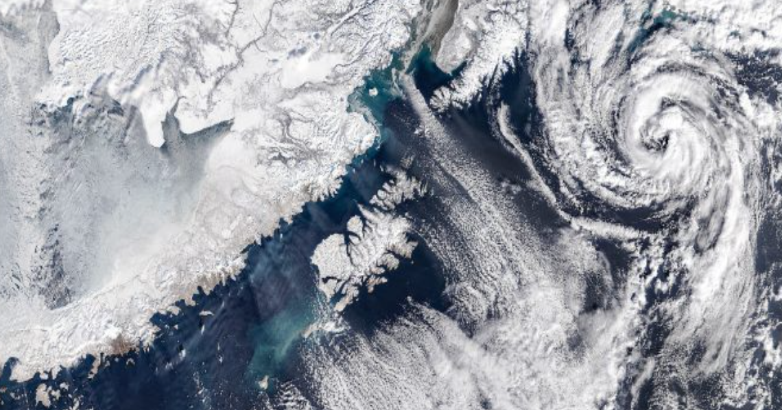
The mesmerizing formations are the direct result of a specific atmospheric interaction. Named after the pioneering Hungarian-American physicist Theodore von Kármán, a vortex street occurs when a fast-moving fluid—such as wind or ocean currents—encounters a solid obstacle. In this instance off the Alaskan coast, the obstacles are the volcanic peaks of the Aleutian Islands, which jut abruptly out of the North Pacific. As prevailing winds push across the open ocean and slam into these elevated landmasses, the smooth airflow is violently disrupted. Instead of flowing neatly around the islands, the wind separates, creating alternating, spinning eddies on the leeward side of the peaks.
Alaska’s Aleutian Island chain is arguably the perfect geographic location on Earth to witness this phenomenon on a massive scale. The islands form a long, relatively linear barrier stretching across the Pacific. Furthermore, this region is globally notorious for its intense, unobstructed low-level winds. When these powerful winds hit the uniform lineup of volcanic islands, the resulting eddies line up in a neat, repeating sequence that can stretch for hundreds of miles downwind. When the moisture in the air is just right, these invisible wind spirals cause clouds to condense along the low-pressure centers of the eddies, rendering the vortex street visible from space.


NASA routinely documents these atmospheric events using its fleet of Earth-observing satellites. Instruments like the Moderate Resolution Imaging Spectroradiometer (MODIS) aboard the Terra and Aqua satellites, as well as the Visible Infrared Imaging Radiometer Suite (VIIRS) on the Suomi NPP satellite, capture high-resolution, true-color images of the planet. Because these cloud formations can span distances larger than entire states, satellite imagery from hundreds of miles above the Earth’s surface is the only effective way to view the complete vortex street in its entirety.
While the public often marvels at these images for their surreal, artistic beauty, atmospheric scientists study them for highly practical reasons. Understanding how air flows over topographic barriers helps researchers refine global weather forecasting models. More importantly, studying von Kármán vortices is crucial for aviation safety. The turbulence generated by these massive, spinning air masses can be hazardous to commercial aircraft. By tracking their formation and behavior via satellite, meteorologists can issue accurate turbulence advisories to pilots navigating the busy Pacific flight routes.
Ultimately, NASA’s captivating images of Alaska’s swirling clouds serve a vital dual purpose. They highlight the elegant, invisible physics shaping our atmosphere while providing critical data that keeps global air travel safe.
NASA Satellite Captures Mesmerizing Swirling Cloud Formations Off Alaska’s Coast